About Bath Historical Maps
October 2024 - The official launch of the new Bath Historical Map took place alongside the launch of the Historical Map of Bath published by the Historic Towns Trust, follow this link to learn about The Historic Towns Trust Map.
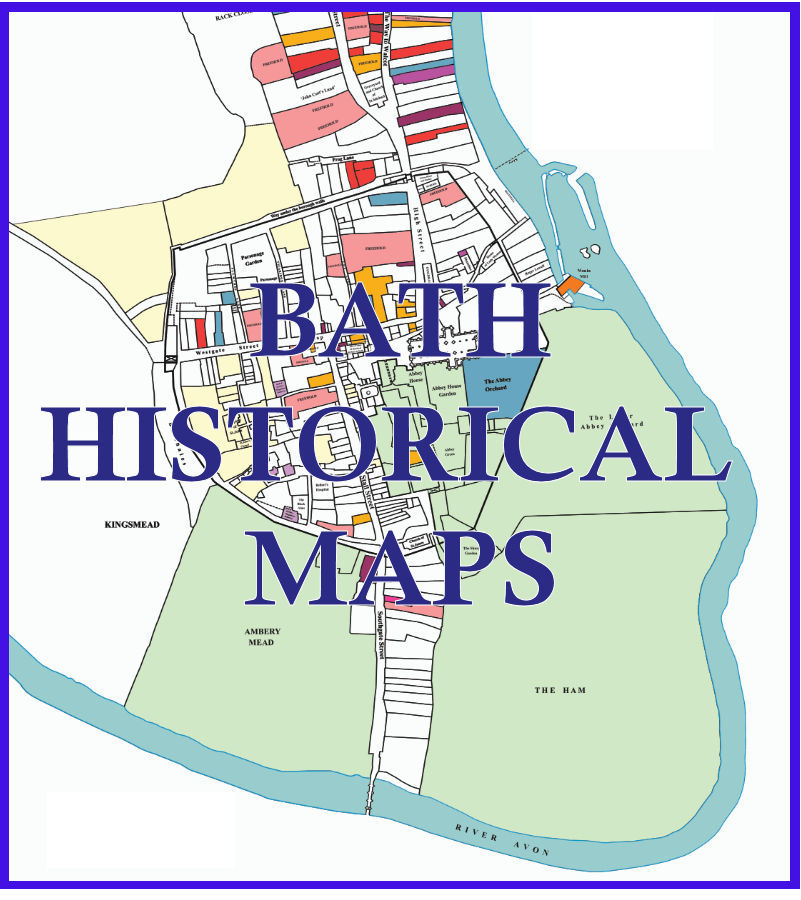
The New Bath Historical Maps Website
This website has been set up to display a range of maps of the City of Bath put together by members of the former Survey of Old Bath and members of the History of Bath Research Group. Work on building the website was begin in March 2024 following the group's involvement with the Historic Towns Trust with a view to produce a new map of the city showing the many layers of its long history, It is hoped that this website will become, like its sister site, Bath Historical Directories a repository for material that is of interest both to those who wish to explore Bath‘s history and those who are actively researching the City.The 1641 Maps
These maps are based around one of the city in 1641. In that year Bath Corporation commissioned a survey of all the properties in the city. This included those within the wall and, Walcot and Southgate without the wall. As the Council controlled four fifths of these properties either by ownership or trusteeship, they held the Deeds and knew the tenants and many of their trades. By exclusion, the remaining properties were in the possession of Freeholders but some names were recorded. The majority of deeds survive and are part of the city archive and are designated by Arts Council England as being of national and international importance. They may be viewed, on appointment, at the Bath Record Office, the accession number for each index entry is supplied by each Furman entry.Thirty years ago Mike Chapman, a former army cartographer, and Miss Elizabeth Holland formed the Friends of the Survey of Old Bath, amongst their goals was the creation of a map of the city in 1641 by stitching together the deeds, drawings and measurements of the sites which are accurate to within less than 12 inches. The precision is greater than any of the earlier maps such as Speed and Savil although those illustrated maps do have their own strengths. The result will be published in paper format by the Historic Towns Trust (details of this map appear on a separate page), with more detailed versions of the map, including details of each tenant, published on this website.
Coloured Map of the Major Landowners and Cloth Trades
The first of the maps to be published will show the major Landowners and the cloth trades within the city in the year 1641. Although wool and its associated trades had begun to decline by this time, the map illustrates just how much the city was still involved in cloth making, from tuckers, fullers, weavers and feltmakers, through tailors and hosiers, to clothiers and mercers. Many of these trades remained in this city and returned in importance as Bath returned to a largely industrial town in the Nineteenth Century.The 1641 Leasehold Map
Drawn from the deeds mentioned above, a more detailed map has been produced which contains a numbered key to the leaseholders within the city. This will be linked to a database containing these names individuals and families, with further details of the type of property, the rent paid and the length of the leases. Additionally this will give access to transcripts of the original deeds.Note: The index number for each deed represent the Page Number:Paragraph Number:Sub-Paragraph Number - e.g. 1:1:1 is Page 1, Paragraph 1, Sub-Paragraph 1. Not all numbers bear a sub-paragraph - e.g. 3:2 is Page 3, and the whole of Paragraph 2
The Roman Map
When the map published by the Historic Towns Trust the decision was taken to take the Roman layer away from the center of the map where it would further complicate and already complex map. Roman finds can be see in the top-left hand corner where it was felt there was space. However, the website offers the opportunity to put this layer back where it belongs, in the centre of the city. A flexible/zoomable map has been added which allows the Roman finds and wall to be viewed along with the 1641 properties and wall, and also the 1885 O/S map of the city.Further Maps and Linking with the Directories
The website offers a real opportunity of tying a number of existing resources together on one website. One of these resources is Bath Historic Directories which already holds more than a third of a million records dating from 1791 to 1935. We look forward to extending these resources to reach a wider audience both of active researchers into the history of the City of Bath, and to others, such as schools and other educational institutions.If you wish to find out more about the Bath Historical Maps website, or have any comments or suggestions related to the content of the website, please complete the Contact Form
This is a free resource developed by volunteers who wish these maps and the data behind them to be made available to the public
Note On Accuracy of Maps and Leaseholder Data